|
|
|||||||||||||||||
| Point ID: 9116 | Downloads | Plots | Site Data | Code: 05AC926 |
|
|
|||||||||||||||||
| Download | |
|---|---|
| Site Descriptor Information | Site Time Series Data |
| Link to all available data | |
| View: | Time Series | All |
| Units: | mm |
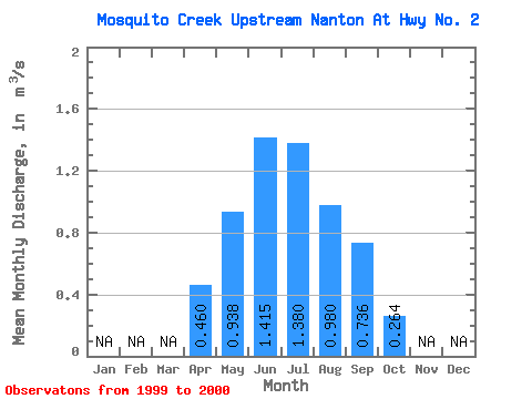
| Statistic | Jan | Feb | Mar | Apr | May | Jun | Jul | Aug | Sep | Oct | Nov | Dec | Annual |
|---|---|---|---|---|---|---|---|---|---|---|---|---|---|
| Mean | 0.46 | 0.94 | 1.42 | 1.38 | 0.98 | 0.74 | 0.26 | ||||||
| Standard Deviation | 0.12 | 0.07 | 0.02 | 0.11 | 0.25 | ||||||||
| Min | 0.38 | 0.89 | 1.40 | 1.30 | 0.80 | 0.74 | 0.26 | ||||||
| Max | 0.54 | 0.99 | 1.43 | 1.46 | 1.16 | 0.74 | 0.26 | ||||||
| Coefficient of Variation | 0.25 | 0.08 | 0.01 | 0.08 | 0.26 |
 Return to R-Arctic Net Home Page