|
|
|||||||||||||||||
| Point ID: 9104 | Downloads | Plots | Site Data | Code: 15518080 |
|
|
|||||||||||||||||
| Download | |
|---|---|
| Site Descriptor Information | Site Time Series Data |
| Link to all available data | |
| View: | Time Series | All |
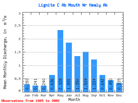
| Units: | mm |
| Statistic | Jan | Feb | Mar | Apr | May | Jun | Jul | Aug | Sep | Oct | Nov | Dec | Annual |
|---|---|---|---|---|---|---|---|---|---|---|---|---|---|
| Mean | 0.28 | 0.24 | 0.24 | 0.64 | 2.33 | 1.85 | 1.35 | 1.51 | 1.22 | 0.64 | 0.45 | 0.34 | 0.88 |
| Standard Deviation | 0.17 | 0.18 | 0.16 | 0.36 | 1.09 | 0.89 | 0.57 | 0.79 | 0.84 | 0.26 | 0.18 | 0.17 | 0.20 |
| Min | 0.03 | 0.00 | 0.00 | 0.00 | 1.14 | 0.85 | 0.72 | 0.64 | 0.50 | 0.29 | 0.14 | 0.05 | 0.53 |
| Max | 0.53 | 0.58 | 0.54 | 1.29 | 4.70 | 4.10 | 2.93 | 3.17 | 3.78 | 1.34 | 0.72 | 0.57 | 1.26 |
| Coefficient of Variation | 0.61 | 0.74 | 0.65 | 0.56 | 0.47 | 0.48 | 0.42 | 0.53 | 0.69 | 0.40 | 0.40 | 0.50 | 0.22 |
 Return to R-Arctic Net Home Page