|
|
|||||||||||||||||
| Point ID: 9095 | Downloads | Plots | Site Data | Code: 123.20.0.1001.1 |
|
|
|||||||||||||||||
| Download | |
|---|---|
| Site Descriptor Information | Site Time Series Data |
| Link to all available data | |
| View: | Time Series | All |
| Units: | mm |
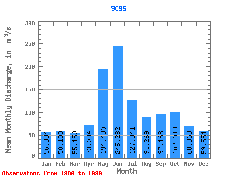
| Statistic | Jan | Feb | Mar | Apr | May | Jun | Jul | Aug | Sep | Oct | Nov | Dec | Annual |
|---|---|---|---|---|---|---|---|---|---|---|---|---|---|
| Mean | 56.89 | 58.19 | 55.15 | 73.03 | 194.49 | 245.28 | 127.34 | 91.27 | 97.17 | 102.02 | 68.86 | 59.55 | 102.44 |
| Standard Deviation | 32.70 | 36.04 | 33.26 | 35.04 | 85.60 | 125.47 | 69.84 | 44.19 | 44.10 | 44.72 | 29.75 | 30.01 | 19.00 |
| Min | 10.92 | 7.16 | 7.92 | 10.19 | 51.10 | 63.04 | 34.92 | 20.10 | 22.25 | 24.07 | 13.95 | 13.42 | 60.96 |
| Max | 128.33 | 163.28 | 145.70 | 156.53 | 460.29 | 613.49 | 425.26 | 253.36 | 243.21 | 252.07 | 140.47 | 137.79 | 154.85 |
| Coefficient of Variation | 0.57 | 0.62 | 0.60 | 0.48 | 0.44 | 0.51 | 0.55 | 0.48 | 0.45 | 0.44 | 0.43 | 0.50 | 0.19 |
 Return to R-Arctic Net Home Page