|
|
|||||||||||||||||
| Point ID: 9060 | Downloads | Plots | Site Data | Code: 49071 |
|
|
|||||||||||||||||
| Download | |
|---|---|
| Site Descriptor Information | Site Time Series Data |
| Link to all available data | |
| View: | Time Series | All |
| Units: | mm |
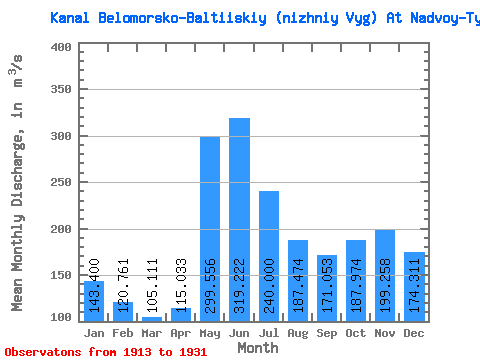
| Statistic | Jan | Feb | Mar | Apr | May | Jun | Jul | Aug | Sep | Oct | Nov | Dec | Annual |
|---|---|---|---|---|---|---|---|---|---|---|---|---|---|
| Mean | 143.40 | 120.76 | 105.11 | 115.03 | 299.56 | 319.22 | 240.00 | 187.47 | 171.05 | 187.97 | 199.26 | 174.31 | 189.33 |
| Standard Deviation | 48.04 | 37.74 | 29.09 | 39.25 | 83.24 | 84.24 | 49.00 | 41.56 | 48.82 | 50.91 | 71.73 | 59.80 | 28.87 |
| Min | 76.10 | 70.00 | 65.00 | 68.70 | 176.00 | 206.00 | 167.00 | 130.00 | 113.00 | 91.50 | 82.90 | 84.90 | 151.07 |
| Max | 248.00 | 218.00 | 182.00 | 213.00 | 527.00 | 552.00 | 330.00 | 306.00 | 292.00 | 267.00 | 379.00 | 300.00 | 250.25 |
| Coefficient of Variation | 0.34 | 0.31 | 0.28 | 0.34 | 0.28 | 0.26 | 0.20 | 0.22 | 0.28 | 0.27 | 0.36 | 0.34 | 0.15 |
 Return to R-Arctic Net Home Page