|
|
|||||||||||||||||
| Point ID: 9051 | Downloads | Plots | Site Data | Code: 49012 |
|
|
|||||||||||||||||
| Download | |
|---|---|
| Site Descriptor Information | Site Time Series Data |
| Link to all available data | |
| View: | Time Series | All |
| Units: | mm |
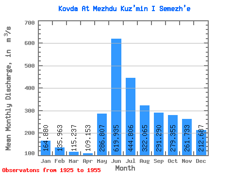
| Statistic | Jan | Feb | Mar | Apr | May | Jun | Jul | Aug | Sep | Oct | Nov | Dec | Annual |
|---|---|---|---|---|---|---|---|---|---|---|---|---|---|
| Mean | 164.88 | 135.96 | 115.24 | 109.15 | 286.81 | 619.93 | 444.81 | 322.06 | 291.29 | 279.36 | 261.73 | 212.69 | 270.85 |
| Standard Deviation | 49.15 | 34.27 | 28.04 | 22.29 | 135.86 | 159.12 | 107.64 | 87.55 | 102.28 | 126.74 | 108.65 | 74.50 | 60.77 |
| Min | 84.10 | 72.20 | 47.90 | 66.30 | 96.20 | 323.00 | 243.00 | 157.00 | 134.00 | 128.00 | 124.00 | 98.60 | 147.41 |
| Max | 263.00 | 198.00 | 164.00 | 149.00 | 558.00 | 890.00 | 683.00 | 517.00 | 490.00 | 733.00 | 591.00 | 374.00 | 418.58 |
| Coefficient of Variation | 0.30 | 0.25 | 0.24 | 0.20 | 0.47 | 0.26 | 0.24 | 0.27 | 0.35 | 0.45 | 0.41 | 0.35 | 0.22 |
 Return to R-Arctic Net Home Page