|
|
|||||||||||||||||
| Point ID: 905 | Downloads | Plots | Site Data | Code: 07GC001 |
|
|
|||||||||||||||||
| Download | |
|---|---|
| Site Descriptor Information | Site Time Series Data |
| Link to all available data | |
| View: | Time Series | All |
| Units: | mm |
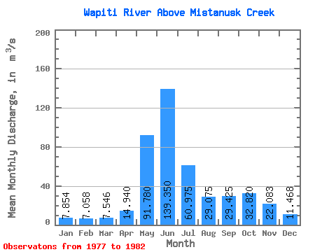
| Statistic | Jan | Feb | Mar | Apr | May | Jun | Jul | Aug | Sep | Oct | Nov | Dec | Annual |
|---|---|---|---|---|---|---|---|---|---|---|---|---|---|
| Mean | 7.85 | 7.06 | 7.55 | 14.94 | 91.78 | 139.35 | 60.98 | 29.07 | 29.43 | 32.82 | 22.08 | 11.47 | 37.97 |
| Standard Deviation | 3.44 | 3.97 | 4.87 | 5.56 | 32.10 | 52.82 | 11.13 | 10.53 | 21.33 | 19.69 | 10.82 | 4.39 | 5.71 |
| Min | 3.95 | 3.80 | 3.50 | 7.30 | 55.20 | 92.60 | 45.20 | 17.30 | 10.90 | 11.80 | 7.70 | 4.80 | 34.45 |
| Max | 13.00 | 13.40 | 15.00 | 20.00 | 143.00 | 189.00 | 71.40 | 41.70 | 55.60 | 56.00 | 38.90 | 16.10 | 46.50 |
| Coefficient of Variation | 0.44 | 0.56 | 0.65 | 0.37 | 0.35 | 0.38 | 0.18 | 0.36 | 0.72 | 0.60 | 0.49 | 0.38 | 0.15 |
 Return to R-Arctic Net Home Page