|
|
|||||||||||||||||
| Point ID: 9041 | Downloads | Plots | Site Data | Code: 71284 |
|
|
|||||||||||||||||
| Download | |
|---|---|
| Site Descriptor Information | Site Time Series Data |
| Link to all available data | |
| View: | Time Series | All |
| Units: | mm |
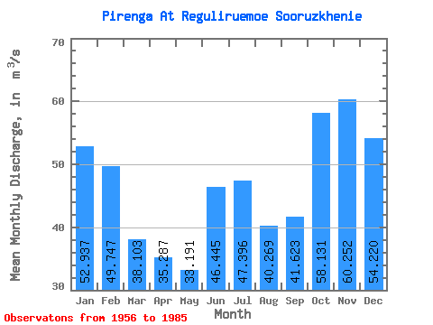
| Statistic | Jan | Feb | Mar | Apr | May | Jun | Jul | Aug | Sep | Oct | Nov | Dec | Annual |
|---|---|---|---|---|---|---|---|---|---|---|---|---|---|
| Mean | 52.94 | 49.75 | 38.10 | 35.29 | 33.19 | 46.45 | 47.40 | 40.27 | 41.62 | 58.13 | 60.25 | 54.22 | 46.47 |
| Standard Deviation | 22.78 | 23.75 | 16.34 | 16.38 | 14.88 | 30.35 | 24.87 | 18.74 | 15.93 | 22.87 | 27.27 | 24.89 | 9.62 |
| Min | 19.00 | 15.80 | 0.10 | 10.00 | 6.24 | 0.00 | 2.48 | 7.88 | 7.70 | 5.92 | 7.85 | 10.00 | 25.61 |
| Max | 110.00 | 107.00 | 69.60 | 74.00 | 66.20 | 109.00 | 105.00 | 109.00 | 83.60 | 113.00 | 101.00 | 98.70 | 61.22 |
| Coefficient of Variation | 0.43 | 0.48 | 0.43 | 0.46 | 0.45 | 0.65 | 0.53 | 0.47 | 0.38 | 0.39 | 0.45 | 0.46 | 0.21 |
 Return to R-Arctic Net Home Page