|
|
|||||||||||||||||
| Point ID: 9007 | Downloads | Plots | Site Data | Code: 71171 |
|
|
|||||||||||||||||
| Download | |
|---|---|
| Site Descriptor Information | Site Time Series Data |
| Link to all available data | |
| View: | Time Series | All |
| Units: | mm |
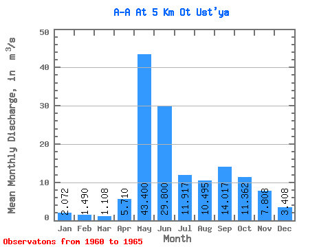
| Statistic | Jan | Feb | Mar | Apr | May | Jun | Jul | Aug | Sep | Oct | Nov | Dec | Annual |
|---|---|---|---|---|---|---|---|---|---|---|---|---|---|
| Mean | 2.07 | 1.49 | 1.11 | 5.71 | 43.40 | 29.80 | 11.92 | 10.49 | 14.02 | 11.36 | 7.81 | 3.41 | 13.35 |
| Standard Deviation | 0.67 | 0.66 | 0.43 | 6.51 | 24.02 | 18.29 | 4.27 | 5.69 | 6.97 | 7.13 | 4.41 | 2.08 | 2.05 |
| Min | 1.46 | 1.07 | 0.68 | 1.05 | 17.70 | 12.70 | 5.18 | 5.05 | 7.45 | 3.64 | 2.49 | 1.34 | 11.37 |
| Max | 3.04 | 2.66 | 1.83 | 18.00 | 72.90 | 65.00 | 16.50 | 17.60 | 22.90 | 22.70 | 14.00 | 6.79 | 15.49 |
| Coefficient of Variation | 0.32 | 0.45 | 0.39 | 1.14 | 0.55 | 0.61 | 0.36 | 0.54 | 0.50 | 0.63 | 0.56 | 0.61 | 0.15 |
 Return to R-Arctic Net Home Page