|
|
|||||||||||||||||
| Point ID: 9002 | Downloads | Plots | Site Data | Code: 71153 |
|
|
|||||||||||||||||
| Download | |
|---|---|
| Site Descriptor Information | Site Time Series Data |
| Link to all available data | |
| View: | Time Series | All |
| Units: | mm |
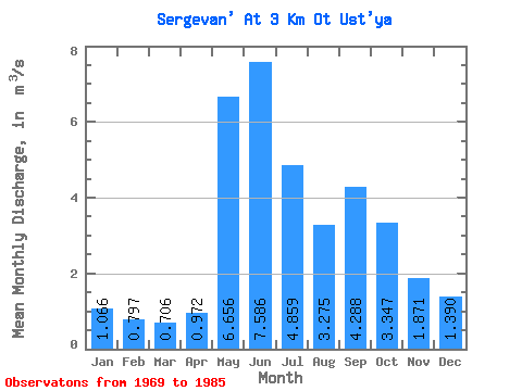
| Statistic | Jan | Feb | Mar | Apr | May | Jun | Jul | Aug | Sep | Oct | Nov | Dec | Annual |
|---|---|---|---|---|---|---|---|---|---|---|---|---|---|
| Mean | 1.07 | 0.80 | 0.71 | 0.97 | 6.66 | 7.59 | 4.86 | 3.27 | 4.29 | 3.35 | 1.87 | 1.39 | 3.12 |
| Standard Deviation | 0.17 | 0.15 | 0.13 | 0.43 | 2.39 | 2.00 | 2.54 | 1.06 | 1.90 | 1.36 | 0.41 | 0.25 | 0.44 |
| Min | 0.73 | 0.47 | 0.39 | 0.61 | 1.94 | 4.19 | 2.16 | 1.61 | 2.08 | 1.43 | 1.14 | 0.95 | 2.40 |
| Max | 1.35 | 1.08 | 0.87 | 2.25 | 11.10 | 10.30 | 9.95 | 4.77 | 7.80 | 6.22 | 2.44 | 1.91 | 3.66 |
| Coefficient of Variation | 0.15 | 0.19 | 0.18 | 0.45 | 0.36 | 0.26 | 0.52 | 0.32 | 0.44 | 0.41 | 0.22 | 0.18 | 0.14 |
 Return to R-Arctic Net Home Page