|
|
|||||||||||||||||
| Point ID: 8993 | Downloads | Plots | Site Data | Code: 71141 |
|
|
|||||||||||||||||
| Download | |
|---|---|
| Site Descriptor Information | Site Time Series Data |
| Link to all available data | |
| View: | Time Series | All |
| Units: | mm |
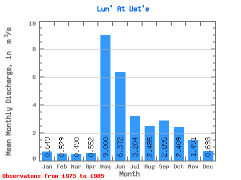
| Statistic | Jan | Feb | Mar | Apr | May | Jun | Jul | Aug | Sep | Oct | Nov | Dec | Annual |
|---|---|---|---|---|---|---|---|---|---|---|---|---|---|
| Mean | 0.65 | 0.53 | 0.49 | 0.55 | 9.00 | 6.37 | 3.20 | 2.48 | 2.90 | 2.41 | 1.49 | 0.69 | 2.54 |
| Standard Deviation | 0.18 | 0.15 | 0.15 | 0.27 | 3.74 | 2.52 | 1.72 | 0.80 | 0.82 | 0.73 | 0.47 | 0.33 | 0.30 |
| Min | 0.35 | 0.32 | 0.27 | 0.28 | 1.55 | 2.64 | 1.28 | 1.27 | 1.54 | 1.71 | 0.95 | 0.12 | 2.04 |
| Max | 0.97 | 0.71 | 0.68 | 1.19 | 13.30 | 9.92 | 7.18 | 3.69 | 4.40 | 3.86 | 2.33 | 1.09 | 2.95 |
| Coefficient of Variation | 0.28 | 0.28 | 0.30 | 0.49 | 0.42 | 0.40 | 0.54 | 0.32 | 0.28 | 0.30 | 0.31 | 0.48 | 0.12 |
 Return to R-Arctic Net Home Page