|
|
|||||||||||||||||
| Point ID: 899 | Downloads | Plots | Site Data | Code: 07FD004 |
|
|
|||||||||||||||||
| Download | |
|---|---|
| Site Descriptor Information | Site Time Series Data |
| Link to all available data | |
| View: | Time Series | All |
| Units: | mm |
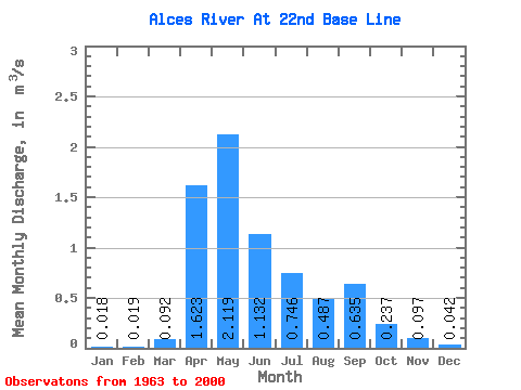
| Statistic | Jan | Feb | Mar | Apr | May | Jun | Jul | Aug | Sep | Oct | Nov | Dec | Annual |
|---|---|---|---|---|---|---|---|---|---|---|---|---|---|
| Mean | 0.02 | 0.02 | 0.09 | 1.62 | 2.12 | 1.13 | 0.75 | 0.49 | 0.64 | 0.24 | 0.10 | 0.04 | 0.57 |
| Standard Deviation | 0.01 | 0.02 | 0.14 | 1.77 | 2.49 | 1.16 | 0.69 | 0.78 | 1.43 | 0.29 | 0.13 | 0.05 | 0.46 |
| Min | 0.00 | 0.00 | 0.00 | 0.04 | 0.14 | 0.17 | 0.00 | 0.00 | 0.00 | 0.00 | 0.00 | 0.00 | 0.14 |
| Max | 0.05 | 0.06 | 0.56 | 5.90 | 10.30 | 4.98 | 2.28 | 2.29 | 5.78 | 0.93 | 0.47 | 0.17 | 1.71 |
| Coefficient of Variation | 0.85 | 0.98 | 1.59 | 1.09 | 1.18 | 1.02 | 0.92 | 1.61 | 2.24 | 1.22 | 1.29 | 1.15 | 0.80 |
 Return to R-Arctic Net Home Page