|
|
|||||||||||||||||
| Point ID: 8987 | Downloads | Plots | Site Data | Code: 71123 |
|
|
|||||||||||||||||
| Download | |
|---|---|
| Site Descriptor Information | Site Time Series Data |
| Link to all available data | |
| View: | Time Series | All |
| Units: | mm |
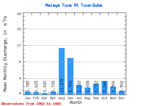
| Statistic | Jan | Feb | Mar | Apr | May | Jun | Jul | Aug | Sep | Oct | Nov | Dec | Annual |
|---|---|---|---|---|---|---|---|---|---|---|---|---|---|
| Mean | 0.79 | 0.62 | 0.43 | 0.73 | 11.38 | 8.95 | 2.33 | 1.66 | 2.71 | 3.35 | 1.97 | 0.90 | 2.98 |
| Standard Deviation | 0.46 | 0.42 | 0.31 | 0.80 | 7.11 | 3.60 | 0.20 | 1.39 | 0.66 | 1.16 | 0.51 | 0.38 | 0.58 |
| Min | 0.39 | 0.27 | 0.17 | 0.14 | 3.58 | 5.75 | 2.06 | 0.83 | 1.91 | 1.88 | 1.48 | 0.60 | 2.32 |
| Max | 1.32 | 1.19 | 0.88 | 1.89 | 20.70 | 13.30 | 2.49 | 3.74 | 3.62 | 4.43 | 2.52 | 1.42 | 3.73 |
| Coefficient of Variation | 0.58 | 0.67 | 0.73 | 1.09 | 0.62 | 0.40 | 0.09 | 0.84 | 0.24 | 0.34 | 0.26 | 0.41 | 0.20 |
 Return to R-Arctic Net Home Page