|
|
|||||||||||||||||
| Point ID: 8972 | Downloads | Plots | Site Data | Code: 71086 |
|
|
|||||||||||||||||
| Download | |
|---|---|
| Site Descriptor Information | Site Time Series Data |
| Link to all available data | |
| View: | Time Series | All |
| Units: | mm |
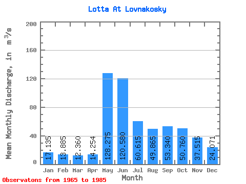
| Statistic | Jan | Feb | Mar | Apr | May | Jun | Jul | Aug | Sep | Oct | Nov | Dec | Annual |
|---|---|---|---|---|---|---|---|---|---|---|---|---|---|
| Mean | 17.14 | 13.88 | 12.36 | 14.25 | 128.28 | 120.58 | 60.62 | 49.87 | 53.34 | 50.76 | 37.52 | 24.07 | 48.52 |
| Standard Deviation | 2.59 | 2.06 | 1.79 | 6.67 | 54.55 | 44.98 | 27.40 | 23.37 | 23.88 | 16.26 | 23.06 | 5.88 | 9.47 |
| Min | 12.60 | 10.10 | 9.91 | 8.82 | 42.00 | 54.40 | 31.60 | 18.40 | 18.50 | 19.80 | 17.70 | 16.30 | 34.56 |
| Max | 23.00 | 18.30 | 16.00 | 41.10 | 218.00 | 212.00 | 146.00 | 122.00 | 119.00 | 89.10 | 129.00 | 41.60 | 69.09 |
| Coefficient of Variation | 0.15 | 0.15 | 0.14 | 0.47 | 0.42 | 0.37 | 0.45 | 0.47 | 0.45 | 0.32 | 0.61 | 0.24 | 0.20 |
 Return to R-Arctic Net Home Page