|
|
|||||||||||||||||
| Point ID: 8966 | Downloads | Plots | Site Data | Code: 71076 |
|
|
|||||||||||||||||
| Download | |
|---|---|
| Site Descriptor Information | Site Time Series Data |
| Link to all available data | |
| View: | Time Series | All |
| Units: | mm |
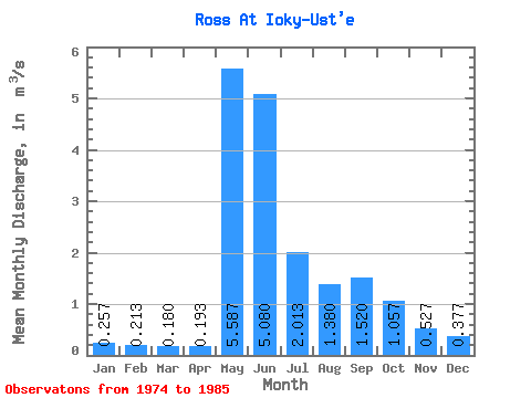
| Statistic | Jan | Feb | Mar | Apr | May | Jun | Jul | Aug | Sep | Oct | Nov | Dec | Annual |
|---|---|---|---|---|---|---|---|---|---|---|---|---|---|
| Mean | 0.26 | 0.21 | 0.18 | 0.19 | 5.59 | 5.08 | 2.01 | 1.38 | 1.52 | 1.06 | 0.53 | 0.38 | 1.25 |
| Standard Deviation | 0.08 | 0.08 | 0.07 | 0.06 | 1.72 | 1.96 | 0.94 | 0.64 | 0.45 | 0.03 | 0.07 | 0.04 | 0.16 |
| Min | 0.19 | 0.14 | 0.11 | 0.11 | 2.25 | 3.20 | 0.92 | 0.61 | 0.85 | 1.03 | 0.45 | 0.34 | 1.14 |
| Max | 0.35 | 0.30 | 0.25 | 0.25 | 6.77 | 8.40 | 3.32 | 3.12 | 2.32 | 1.09 | 0.59 | 0.42 | 1.36 |
| Coefficient of Variation | 0.32 | 0.38 | 0.39 | 0.32 | 0.31 | 0.39 | 0.47 | 0.47 | 0.30 | 0.03 | 0.14 | 0.11 | 0.13 |
 Return to R-Arctic Net Home Page