|
|
|||||||||||||||||
| Point ID: 8964 | Downloads | Plots | Site Data | Code: 71066 |
|
|
|||||||||||||||||
| Download | |
|---|---|
| Site Descriptor Information | Site Time Series Data |
| Link to all available data | |
| View: | Time Series | All |
| Units: | mm |
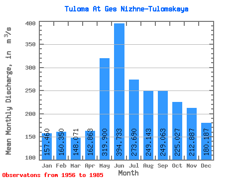
| Statistic | Jan | Feb | Mar | Apr | May | Jun | Jul | Aug | Sep | Oct | Nov | Dec | Annual |
|---|---|---|---|---|---|---|---|---|---|---|---|---|---|
| Mean | 157.46 | 160.35 | 148.07 | 162.86 | 319.90 | 394.73 | 273.69 | 249.14 | 249.06 | 225.03 | 212.89 | 180.19 | 227.78 |
| Standard Deviation | 64.15 | 74.39 | 76.19 | 73.85 | 153.83 | 217.78 | 145.06 | 108.28 | 83.71 | 83.77 | 81.34 | 67.82 | 50.36 |
| Min | 17.40 | 16.60 | 9.02 | 21.60 | 165.00 | 131.00 | 74.70 | 84.90 | 94.90 | 63.30 | 30.80 | 23.60 | 105.06 |
| Max | 259.00 | 278.00 | 278.00 | 273.00 | 797.00 | 933.00 | 694.00 | 520.00 | 417.00 | 410.00 | 358.00 | 285.00 | 296.42 |
| Coefficient of Variation | 0.41 | 0.46 | 0.52 | 0.45 | 0.48 | 0.55 | 0.53 | 0.43 | 0.34 | 0.37 | 0.38 | 0.38 | 0.22 |
 Return to R-Arctic Net Home Page