|
|
|||||||||||||||||
| Point ID: 894 | Downloads | Plots | Site Data | Code: 07FC004 |
|
|
|||||||||||||||||
| Download | |
|---|---|
| Site Descriptor Information | Site Time Series Data |
| Link to all available data | |
| View: | Time Series | All |
| Units: | mm |
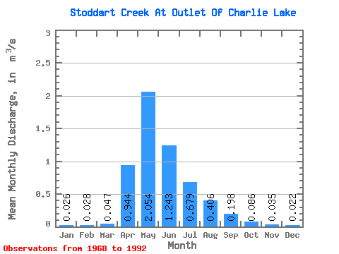
| Statistic | Jan | Feb | Mar | Apr | May | Jun | Jul | Aug | Sep | Oct | Nov | Dec | Annual |
|---|---|---|---|---|---|---|---|---|---|---|---|---|---|
| Mean | 0.03 | 0.03 | 0.05 | 0.94 | 2.05 | 1.24 | 0.68 | 0.41 | 0.20 | 0.09 | 0.04 | 0.02 | 0.47 |
| Standard Deviation | 0.04 | 0.04 | 0.06 | 1.09 | 2.25 | 1.51 | 0.75 | 0.67 | 0.38 | 0.16 | 0.07 | 0.04 | 0.38 |
| Min | 0.00 | 0.00 | 0.00 | 0.00 | 0.00 | 0.01 | 0.01 | 0.00 | 0.00 | 0.00 | 0.00 | 0.00 | 0.02 |
| Max | 0.10 | 0.12 | 0.17 | 3.73 | 7.13 | 5.93 | 2.29 | 2.38 | 1.37 | 0.48 | 0.27 | 0.10 | 1.18 |
| Coefficient of Variation | 1.42 | 1.55 | 1.27 | 1.16 | 1.10 | 1.22 | 1.11 | 1.64 | 1.91 | 1.83 | 2.10 | 1.58 | 0.80 |
 Return to R-Arctic Net Home Page