|
|
|||||||||||||||||
| Point ID: 8907 | Downloads | Plots | Site Data | Code: 70568 |
|
|
|||||||||||||||||
| Download | |
|---|---|
| Site Descriptor Information | Site Time Series Data |
| Link to all available data | |
| View: | Time Series | All |
| Units: | mm |
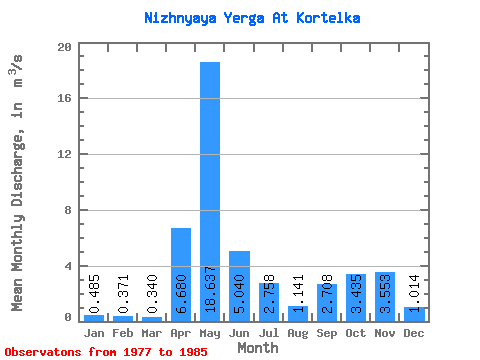
| Statistic | Jan | Feb | Mar | Apr | May | Jun | Jul | Aug | Sep | Oct | Nov | Dec | Annual |
|---|---|---|---|---|---|---|---|---|---|---|---|---|---|
| Mean | 0.48 | 0.37 | 0.34 | 6.68 | 18.64 | 5.04 | 2.76 | 1.14 | 2.71 | 3.44 | 3.55 | 1.01 | 3.69 |
| Standard Deviation | 0.26 | 0.15 | 0.09 | 6.89 | 8.17 | 4.50 | 2.20 | 0.72 | 1.82 | 1.98 | 2.69 | 0.62 | 0.61 |
| Min | 0.16 | 0.22 | 0.25 | 0.34 | 4.30 | 0.92 | 0.42 | 0.38 | 0.55 | 1.53 | 1.39 | 0.55 | 2.54 |
| Max | 0.88 | 0.64 | 0.44 | 18.40 | 33.60 | 14.30 | 5.74 | 2.51 | 5.96 | 6.78 | 8.34 | 2.56 | 4.44 |
| Coefficient of Variation | 0.54 | 0.41 | 0.28 | 1.03 | 0.44 | 0.89 | 0.80 | 0.64 | 0.67 | 0.58 | 0.76 | 0.61 | 0.17 |
 Return to R-Arctic Net Home Page