|
|
|||||||||||||||||
| Point ID: 8848 | Downloads | Plots | Site Data | Code: 70208 |
|
|
|||||||||||||||||
| Download | |
|---|---|
| Site Descriptor Information | Site Time Series Data |
| Link to all available data | |
| View: | Time Series | All |
| Units: | mm |
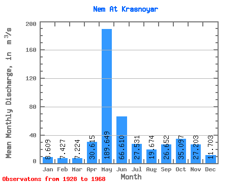
| Statistic | Jan | Feb | Mar | Apr | May | Jun | Jul | Aug | Sep | Oct | Nov | Dec | Annual |
|---|---|---|---|---|---|---|---|---|---|---|---|---|---|
| Mean | 8.61 | 7.43 | 7.22 | 30.61 | 189.65 | 66.61 | 27.53 | 19.67 | 26.65 | 35.10 | 27.20 | 11.70 | 38.20 |
| Standard Deviation | 2.00 | 1.61 | 1.62 | 27.35 | 56.39 | 32.57 | 16.27 | 14.69 | 28.36 | 15.74 | 14.95 | 4.48 | 7.89 |
| Min | 5.25 | 3.50 | 2.30 | 3.49 | 82.60 | 17.40 | 10.30 | 6.87 | 6.14 | 10.30 | 6.41 | 5.62 | 17.94 |
| Max | 12.30 | 10.90 | 10.40 | 128.00 | 301.00 | 158.00 | 73.10 | 74.70 | 176.00 | 75.20 | 65.70 | 27.00 | 56.49 |
| Coefficient of Variation | 0.23 | 0.22 | 0.23 | 0.89 | 0.30 | 0.49 | 0.59 | 0.75 | 1.06 | 0.45 | 0.55 | 0.38 | 0.21 |
 Return to R-Arctic Net Home Page