|
|
|||||||||||||||||
| Point ID: 8846 | Downloads | Plots | Site Data | Code: 70157 |
|
|
|||||||||||||||||
| Download | |
|---|---|
| Site Descriptor Information | Site Time Series Data |
| Link to all available data | |
| View: | Time Series | All |
| Units: | mm |
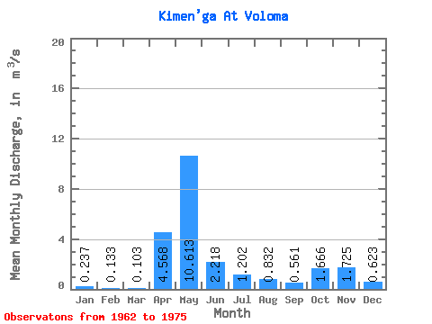
| Statistic | Jan | Feb | Mar | Apr | May | Jun | Jul | Aug | Sep | Oct | Nov | Dec | Annual |
|---|---|---|---|---|---|---|---|---|---|---|---|---|---|
| Mean | 0.24 | 0.13 | 0.10 | 4.57 | 10.61 | 2.22 | 1.20 | 0.83 | 0.56 | 1.67 | 1.73 | 0.62 | 2.07 |
| Standard Deviation | 0.13 | 0.05 | 0.03 | 3.92 | 5.75 | 1.38 | 1.73 | 1.25 | 0.52 | 1.07 | 0.94 | 0.39 | 0.60 |
| Min | 0.06 | 0.07 | 0.05 | 0.52 | 2.73 | 0.22 | 0.11 | 0.12 | 0.17 | 0.28 | 0.40 | 0.17 | 1.30 |
| Max | 0.51 | 0.23 | 0.14 | 12.50 | 19.80 | 5.78 | 6.12 | 4.07 | 2.11 | 3.83 | 3.09 | 1.62 | 3.23 |
| Coefficient of Variation | 0.53 | 0.39 | 0.28 | 0.86 | 0.54 | 0.62 | 1.44 | 1.50 | 0.93 | 0.64 | 0.54 | 0.62 | 0.29 |
 Return to R-Arctic Net Home Page