|
|
|||||||||||||||||
| Point ID: 8845 | Downloads | Plots | Site Data | Code: 70144 |
|
|
|||||||||||||||||
| Download | |
|---|---|
| Site Descriptor Information | Site Time Series Data |
| Link to all available data | |
| View: | Time Series | All |
| Units: | mm |
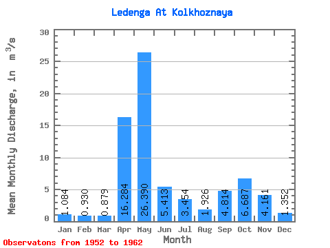
| Statistic | Jan | Feb | Mar | Apr | May | Jun | Jul | Aug | Sep | Oct | Nov | Dec | Annual |
|---|---|---|---|---|---|---|---|---|---|---|---|---|---|
| Mean | 1.08 | 0.93 | 0.88 | 16.28 | 26.39 | 5.41 | 3.45 | 1.93 | 4.81 | 6.69 | 4.16 | 1.35 | 5.96 |
| Standard Deviation | 0.48 | 0.33 | 0.31 | 10.39 | 16.53 | 4.82 | 2.77 | 1.21 | 5.83 | 3.85 | 2.85 | 0.47 | 1.22 |
| Min | 0.44 | 0.53 | 0.32 | 2.62 | 6.16 | 1.38 | 0.88 | 0.43 | 0.80 | 1.84 | 1.22 | 0.63 | 3.04 |
| Max | 1.85 | 1.50 | 1.22 | 33.10 | 58.60 | 16.60 | 8.28 | 4.54 | 18.40 | 12.60 | 10.30 | 2.33 | 7.29 |
| Coefficient of Variation | 0.45 | 0.36 | 0.35 | 0.64 | 0.63 | 0.89 | 0.80 | 0.62 | 1.21 | 0.57 | 0.69 | 0.35 | 0.20 |
 Return to R-Arctic Net Home Page