|
|
|||||||||||||||||
| Point ID: 8842 | Downloads | Plots | Site Data | Code: 70119 |
|
|
|||||||||||||||||
| Download | |
|---|---|
| Site Descriptor Information | Site Time Series Data |
| Link to all available data | |
| View: | Time Series | All |
| Units: | mm |
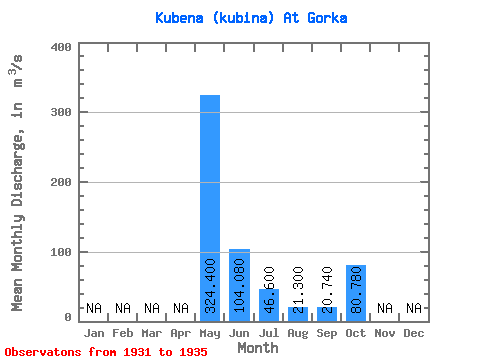
| Statistic | Jan | Feb | Mar | Apr | May | Jun | Jul | Aug | Sep | Oct | Nov | Dec | Annual |
|---|---|---|---|---|---|---|---|---|---|---|---|---|---|
| Mean | 324.40 | 104.08 | 46.60 | 21.30 | 20.74 | 80.78 | |||||||
| Standard Deviation | 76.41 | 24.75 | 49.23 | 19.30 | 9.93 | 54.92 | |||||||
| Min | 244.00 | 64.40 | 18.10 | 10.20 | 10.80 | 42.90 | |||||||
| Max | 414.00 | 129.00 | 134.00 | 55.60 | 34.70 | 176.00 | |||||||
| Coefficient of Variation | 0.24 | 0.24 | 1.06 | 0.91 | 0.48 | 0.68 |
 Return to R-Arctic Net Home Page