|
|
|||||||||||||||||
| Point ID: 8822 | Downloads | Plots | Site Data | Code: 12396 |
|
|
|||||||||||||||||
| Download | |
|---|---|
| Site Descriptor Information | Site Time Series Data |
| Link to all available data | |
| View: | Time Series | All |
| Units: | mm |
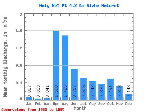
| Statistic | Jan | Feb | Mar | Apr | May | Jun | Jul | Aug | Sep | Oct | Nov | Dec | Annual |
|---|---|---|---|---|---|---|---|---|---|---|---|---|---|
| Mean | 0.07 | 0.03 | 0.04 | 1.59 | 1.48 | 0.72 | 0.52 | 0.44 | 0.37 | 0.49 | 0.32 | 0.14 | 0.52 |
| Standard Deviation | 0.06 | 0.04 | 0.05 | 1.19 | 1.16 | 0.42 | 0.57 | 0.59 | 0.45 | 0.55 | 0.40 | 0.15 | 0.28 |
| Min | 0.00 | 0.00 | 0.00 | 0.15 | 0.06 | 0.08 | 0.02 | 0.01 | 0.00 | 0.01 | 0.01 | 0.00 | 0.07 |
| Max | 0.19 | 0.10 | 0.14 | 4.28 | 4.88 | 1.48 | 2.18 | 2.67 | 1.76 | 2.19 | 1.53 | 0.59 | 1.00 |
| Coefficient of Variation | 0.95 | 1.19 | 1.25 | 0.74 | 0.78 | 0.58 | 1.10 | 1.32 | 1.23 | 1.13 | 1.24 | 1.05 | 0.54 |
 Return to R-Arctic Net Home Page