|
|
|||||||||||||||||
| Point ID: 8817 | Downloads | Plots | Site Data | Code: 12386 |
|
|
|||||||||||||||||
| Download | |
|---|---|
| Site Descriptor Information | Site Time Series Data |
| Link to all available data | |
| View: | Time Series | All |
| Units: | mm |
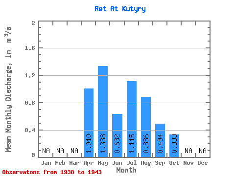
| Statistic | Jan | Feb | Mar | Apr | May | Jun | Jul | Aug | Sep | Oct | Nov | Dec | Annual |
|---|---|---|---|---|---|---|---|---|---|---|---|---|---|
| Mean | 1.01 | 1.34 | 0.63 | 1.11 | 0.89 | 0.49 | 0.33 | ||||||
| Standard Deviation | 1.21 | 0.54 | 1.67 | 1.65 | 0.80 | 0.33 | |||||||
| Min | 1.01 | 0.02 | 0.11 | 0.03 | 0.03 | 0.05 | 0.02 | ||||||
| Max | 1.01 | 3.26 | 1.38 | 4.00 | 4.24 | 2.11 | 0.74 | ||||||
| Coefficient of Variation | 0.90 | 0.85 | 1.50 | 1.86 | 1.62 | 0.99 |
 Return to R-Arctic Net Home Page