|
|
|||||||||||||||||
| Point ID: 881 | Downloads | Plots | Site Data | Code: 07FB002 |
|
|
|||||||||||||||||
| Download | |
|---|---|
| Site Descriptor Information | Site Time Series Data |
| Link to all available data | |
| View: | Time Series | All |
| Units: | mm |
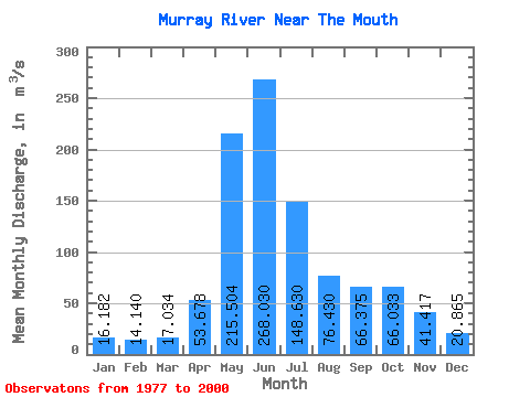
| Statistic | Jan | Feb | Mar | Apr | May | Jun | Jul | Aug | Sep | Oct | Nov | Dec | Annual |
|---|---|---|---|---|---|---|---|---|---|---|---|---|---|
| Mean | 16.18 | 14.14 | 17.03 | 53.68 | 215.50 | 268.03 | 148.63 | 76.43 | 66.38 | 66.03 | 41.42 | 20.86 | 83.45 |
| Standard Deviation | 4.38 | 4.18 | 7.46 | 27.89 | 61.96 | 87.26 | 62.33 | 35.71 | 40.45 | 37.84 | 18.71 | 6.19 | 16.24 |
| Min | 8.53 | 8.30 | 7.72 | 17.40 | 98.60 | 89.70 | 56.70 | 32.40 | 24.20 | 30.00 | 12.20 | 9.47 | 51.69 |
| Max | 27.20 | 28.20 | 40.40 | 115.00 | 358.00 | 466.00 | 311.00 | 183.00 | 164.00 | 187.00 | 96.70 | 36.80 | 118.30 |
| Coefficient of Variation | 0.27 | 0.30 | 0.44 | 0.52 | 0.29 | 0.33 | 0.42 | 0.47 | 0.61 | 0.57 | 0.45 | 0.30 | 0.20 |
 Return to R-Arctic Net Home Page