|
|
|||||||||||||||||
| Point ID: 8791 | Downloads | Plots | Site Data | Code: 12226 |
|
|
|||||||||||||||||
| Download | |
|---|---|
| Site Descriptor Information | Site Time Series Data |
| Link to all available data | |
| View: | Time Series | All |
| Units: | mm |
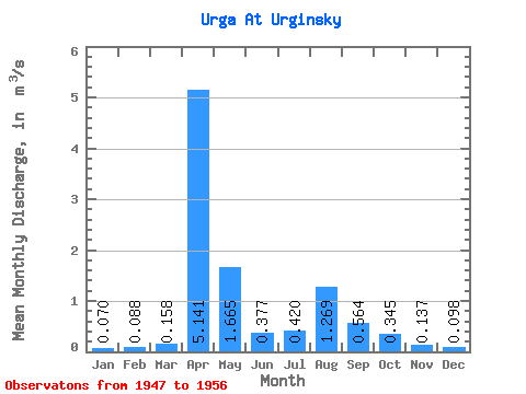
| Statistic | Jan | Feb | Mar | Apr | May | Jun | Jul | Aug | Sep | Oct | Nov | Dec | Annual |
|---|---|---|---|---|---|---|---|---|---|---|---|---|---|
| Mean | 0.07 | 0.09 | 0.16 | 5.14 | 1.67 | 0.38 | 0.42 | 1.27 | 0.56 | 0.34 | 0.14 | 0.10 | 0.29 |
| Standard Deviation | 0.06 | 0.06 | 0.16 | 5.87 | 3.03 | 0.26 | 0.47 | 3.15 | 0.71 | 0.38 | 0.08 | 0.06 | 0.01 |
| Min | 0.00 | 0.03 | 0.04 | 1.56 | 0.21 | 0.15 | 0.01 | 0.00 | 0.13 | 0.07 | 0.00 | 0.00 | 0.29 |
| Max | 0.17 | 0.16 | 0.44 | 16.00 | 10.20 | 0.96 | 1.48 | 10.20 | 2.30 | 1.28 | 0.24 | 0.15 | 0.30 |
| Coefficient of Variation | 0.90 | 0.67 | 1.03 | 1.14 | 1.82 | 0.69 | 1.12 | 2.48 | 1.25 | 1.09 | 0.57 | 0.60 | 0.02 |
 Return to R-Arctic Net Home Page