|
|
|||||||||||||||||
| Point ID: 8789 | Downloads | Plots | Site Data | Code: 12214 |
|
|
|||||||||||||||||
| Download | |
|---|---|
| Site Descriptor Information | Site Time Series Data |
| Link to all available data | |
| View: | Time Series | All |
| Units: | mm |
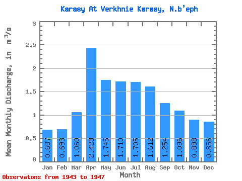
| Statistic | Jan | Feb | Mar | Apr | May | Jun | Jul | Aug | Sep | Oct | Nov | Dec | Annual |
|---|---|---|---|---|---|---|---|---|---|---|---|---|---|
| Mean | 0.69 | 0.69 | 1.06 | 2.42 | 1.75 | 1.71 | 1.71 | 1.61 | 1.25 | 1.10 | 0.90 | 0.86 | 1.19 |
| Standard Deviation | 0.46 | 0.42 | 0.50 | 1.33 | 1.26 | 1.06 | 1.02 | 0.63 | 0.50 | 0.69 | 0.57 | 0.45 | 0.61 |
| Min | 0.24 | 0.23 | 0.59 | 1.00 | 0.34 | 0.68 | 0.76 | 0.66 | 0.59 | 0.40 | 0.19 | 0.29 | 0.66 |
| Max | 1.15 | 1.06 | 1.59 | 3.63 | 3.08 | 2.86 | 3.14 | 2.10 | 1.90 | 2.19 | 1.67 | 1.52 | 1.86 |
| Coefficient of Variation | 0.66 | 0.61 | 0.47 | 0.55 | 0.72 | 0.62 | 0.60 | 0.39 | 0.40 | 0.63 | 0.63 | 0.53 | 0.52 |
 Return to R-Arctic Net Home Page