|
|
|||||||||||||||||
| Point ID: 8769 | Downloads | Plots | Site Data | Code: 12076 |
|
|
|||||||||||||||||
| Download | |
|---|---|
| Site Descriptor Information | Site Time Series Data |
| Link to all available data | |
| View: | Time Series | All |
| Units: | mm |
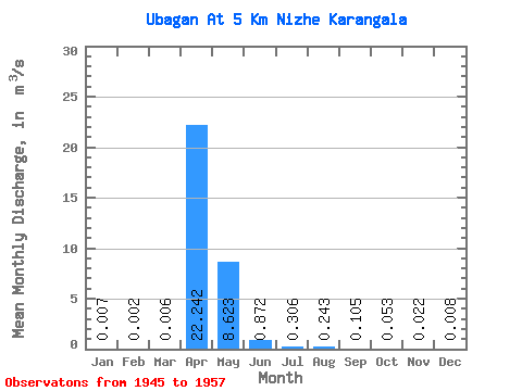
| Statistic | Jan | Feb | Mar | Apr | May | Jun | Jul | Aug | Sep | Oct | Nov | Dec | Annual |
|---|---|---|---|---|---|---|---|---|---|---|---|---|---|
| Mean | 0.01 | 0.00 | 0.01 | 22.24 | 8.62 | 0.87 | 0.31 | 0.24 | 0.10 | 0.05 | 0.02 | 0.01 | 2.71 |
| Standard Deviation | 0.02 | 0.01 | 0.02 | 45.85 | 11.23 | 0.98 | 0.53 | 0.41 | 0.15 | 0.06 | 0.02 | 0.01 | 4.62 |
| Min | 0.00 | 0.00 | 0.00 | 0.06 | 0.13 | 0.04 | 0.01 | 0.00 | 0.00 | 0.00 | 0.00 | 0.00 | 0.04 |
| Max | 0.09 | 0.02 | 0.07 | 166.00 | 39.10 | 3.29 | 1.89 | 1.28 | 0.36 | 0.18 | 0.07 | 0.05 | 16.23 |
| Coefficient of Variation | 3.14 | 3.61 | 3.50 | 2.06 | 1.30 | 1.12 | 1.72 | 1.67 | 1.40 | 1.04 | 0.98 | 1.75 | 1.71 |
 Return to R-Arctic Net Home Page