|
|
|||||||||||||||||
| Point ID: 876 | Downloads | Plots | Site Data | Code: 07FA003 |
|
|
|||||||||||||||||
| Download | |
|---|---|
| Site Descriptor Information | Site Time Series Data |
| Link to all available data | |
| View: | Time Series | All |
| Units: | mm |
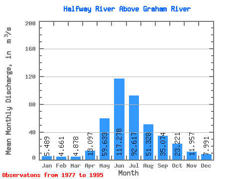
| Statistic | Jan | Feb | Mar | Apr | May | Jun | Jul | Aug | Sep | Oct | Nov | Dec | Annual |
|---|---|---|---|---|---|---|---|---|---|---|---|---|---|
| Mean | 5.49 | 4.66 | 4.88 | 13.10 | 59.63 | 117.28 | 92.62 | 51.33 | 35.07 | 23.22 | 11.96 | 7.99 | 35.43 |
| Standard Deviation | 1.31 | 0.97 | 0.87 | 6.29 | 28.41 | 46.62 | 45.28 | 44.40 | 15.09 | 8.62 | 3.49 | 1.91 | 8.23 |
| Min | 3.17 | 2.38 | 3.14 | 7.42 | 19.30 | 61.80 | 30.20 | 11.20 | 13.30 | 11.20 | 6.88 | 4.66 | 23.91 |
| Max | 7.40 | 6.34 | 6.75 | 28.80 | 121.00 | 259.00 | 179.00 | 178.00 | 63.80 | 38.20 | 19.10 | 11.60 | 51.39 |
| Coefficient of Variation | 0.24 | 0.21 | 0.18 | 0.48 | 0.48 | 0.40 | 0.49 | 0.86 | 0.43 | 0.37 | 0.29 | 0.24 | 0.23 |
 Return to R-Arctic Net Home Page