|
|
|||||||||||||||||
| Point ID: 8747 | Downloads | Plots | Site Data | Code: 12633 |
|
|
|||||||||||||||||
| Download | |
|---|---|
| Site Descriptor Information | Site Time Series Data |
| Link to all available data | |
| View: | Time Series | All |
| Units: | mm |
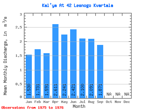
| Statistic | Jan | Feb | Mar | Apr | May | Jun | Jul | Aug | Sep | Oct | Nov | Dec | Annual |
|---|---|---|---|---|---|---|---|---|---|---|---|---|---|
| Mean | 1.53 | 1.73 | 1.59 | 2.61 | 2.24 | 2.42 | 2.10 | 2.09 | 1.87 | ||||
| Standard Deviation | 0.61 | ||||||||||||
| Min | 1.53 | 1.73 | 1.59 | 2.61 | 2.24 | 1.99 | 2.10 | 2.09 | 1.87 | ||||
| Max | 1.53 | 1.73 | 1.59 | 2.61 | 2.24 | 2.85 | 2.10 | 2.09 | 1.87 | ||||
| Coefficient of Variation | 0.25 |
 Return to R-Arctic Net Home Page