|
|
|||||||||||||||||
| Point ID: 8708 | Downloads | Plots | Site Data | Code: 11673 |
|
|
|||||||||||||||||
| Download | |
|---|---|
| Site Descriptor Information | Site Time Series Data |
| Link to all available data | |
| View: | Time Series | All |
| Units: | mm |
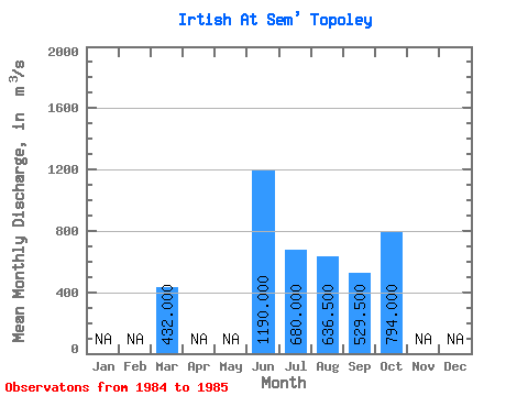
| Statistic | Jan | Feb | Mar | Apr | May | Jun | Jul | Aug | Sep | Oct | Nov | Dec | Annual |
|---|---|---|---|---|---|---|---|---|---|---|---|---|---|
| Mean | 432.00 | 1190.00 | 680.00 | 636.50 | 529.50 | 794.00 | |||||||
| Standard Deviation | 65.05 | 26.16 | 21.92 | 80.61 | |||||||||
| Min | 432.00 | 1190.00 | 634.00 | 618.00 | 514.00 | 737.00 | |||||||
| Max | 432.00 | 1190.00 | 726.00 | 655.00 | 545.00 | 851.00 | |||||||
| Coefficient of Variation | 0.10 | 0.04 | 0.04 | 0.10 |
 Return to R-Arctic Net Home Page