|
|
|||||||||||||||||
| Point ID: 870 | Downloads | Plots | Site Data | Code: 07EE007 |
|
|
|||||||||||||||||
| Download | |
|---|---|
| Site Descriptor Information | Site Time Series Data |
| Link to all available data | |
| View: | Time Series | All |
| Units: | mm |
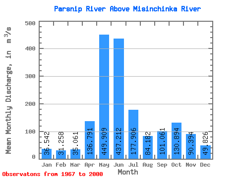
| Statistic | Jan | Feb | Mar | Apr | May | Jun | Jul | Aug | Sep | Oct | Nov | Dec | Annual |
|---|---|---|---|---|---|---|---|---|---|---|---|---|---|
| Mean | 36.54 | 31.26 | 35.06 | 136.79 | 449.91 | 437.21 | 177.91 | 84.18 | 101.06 | 130.89 | 90.39 | 49.83 | 146.71 |
| Standard Deviation | 18.09 | 16.50 | 20.58 | 63.21 | 95.48 | 150.64 | 75.02 | 38.93 | 59.73 | 53.65 | 33.91 | 25.87 | 23.65 |
| Min | 20.40 | 11.70 | 13.00 | 21.30 | 275.00 | 139.00 | 57.10 | 32.80 | 28.90 | 52.00 | 37.10 | 26.50 | 101.80 |
| Max | 88.70 | 91.40 | 113.00 | 302.00 | 628.00 | 741.00 | 374.00 | 201.00 | 264.00 | 275.00 | 160.00 | 163.00 | 199.88 |
| Coefficient of Variation | 0.49 | 0.53 | 0.59 | 0.46 | 0.21 | 0.34 | 0.42 | 0.46 | 0.59 | 0.41 | 0.38 | 0.52 | 0.16 |
 Return to R-Arctic Net Home Page