|
|
|||||||||||||||||
| Point ID: 8696 | Downloads | Plots | Site Data | Code: 11623 |
|
|
|||||||||||||||||
| Download | |
|---|---|
| Site Descriptor Information | Site Time Series Data |
| Link to all available data | |
| View: | Time Series | All |
| Units: | mm |
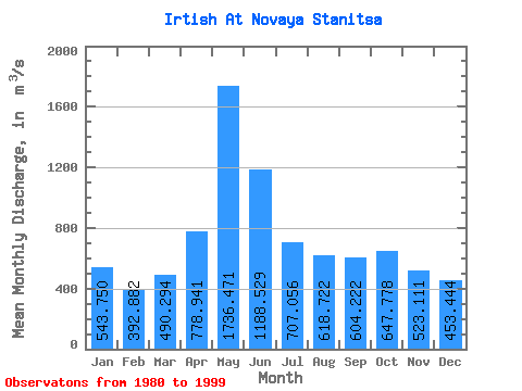
| Statistic | Jan | Feb | Mar | Apr | May | Jun | Jul | Aug | Sep | Oct | Nov | Dec | Annual |
|---|---|---|---|---|---|---|---|---|---|---|---|---|---|
| Mean | 543.75 | 392.88 | 490.29 | 778.94 | 1736.47 | 1188.53 | 707.06 | 618.72 | 604.22 | 647.78 | 523.11 | 453.44 | 764.51 |
| Standard Deviation | 87.82 | 258.34 | 161.74 | 234.52 | 217.97 | 320.09 | 139.50 | 120.11 | 127.13 | 103.39 | 122.32 | 136.27 | 92.19 |
| Min | 390.00 | 5.00 | 256.00 | 385.00 | 1100.00 | 721.00 | 485.00 | 435.00 | 409.00 | 471.00 | 332.00 | 212.00 | 619.25 |
| Max | 706.00 | 797.00 | 857.00 | 1290.00 | 2010.00 | 1740.00 | 1050.00 | 871.00 | 872.00 | 848.00 | 855.00 | 709.00 | 925.08 |
| Coefficient of Variation | 0.16 | 0.66 | 0.33 | 0.30 | 0.13 | 0.27 | 0.20 | 0.19 | 0.21 | 0.16 | 0.23 | 0.30 | 0.12 |
 Return to R-Arctic Net Home Page