|
|
|||||||||||||||||
| Point ID: 8692 | Downloads | Plots | Site Data | Code: 11609 |
|
|
|||||||||||||||||
| Download | |
|---|---|
| Site Descriptor Information | Site Time Series Data |
| Link to all available data | |
| View: | Time Series | All |
| Units: | mm |
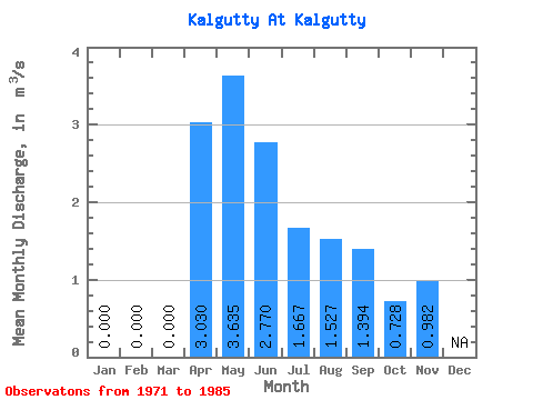
| Statistic | Jan | Feb | Mar | Apr | May | Jun | Jul | Aug | Sep | Oct | Nov | Dec | Annual |
|---|---|---|---|---|---|---|---|---|---|---|---|---|---|
| Mean | 0.00 | 0.00 | 0.00 | 3.03 | 3.63 | 2.77 | 1.67 | 1.53 | 1.39 | 0.73 | 0.98 | ||
| Standard Deviation | 0.00 | 0.00 | 0.00 | 2.42 | 2.10 | 2.73 | 1.52 | 1.37 | 1.21 | 0.30 | 0.40 | ||
| Min | 0.00 | 0.00 | 0.00 | 0.64 | 0.52 | 0.23 | 0.19 | 0.18 | 0.26 | 0.36 | 0.47 | ||
| Max | 0.00 | 0.00 | 0.00 | 7.33 | 8.16 | 10.20 | 4.66 | 4.16 | 3.75 | 1.18 | 1.58 | ||
| Coefficient of Variation | 0.80 | 0.58 | 0.99 | 0.91 | 0.90 | 0.87 | 0.41 | 0.41 |
 Return to R-Arctic Net Home Page