|
|
|||||||||||||||||
| Point ID: 8688 | Downloads | Plots | Site Data | Code: 11605 |
|
|
|||||||||||||||||
| Download | |
|---|---|
| Site Descriptor Information | Site Time Series Data |
| Link to all available data | |
| View: | Time Series | All |
| Units: | mm |
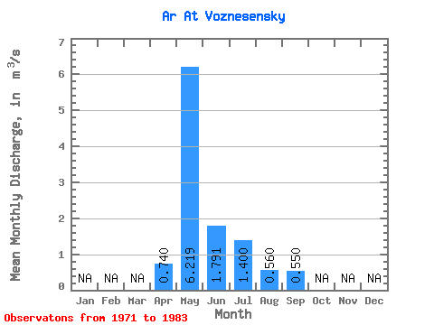
| Statistic | Jan | Feb | Mar | Apr | May | Jun | Jul | Aug | Sep | Oct | Nov | Dec | Annual |
|---|---|---|---|---|---|---|---|---|---|---|---|---|---|
| Mean | 0.74 | 6.22 | 1.79 | 1.40 | 0.56 | 0.55 | |||||||
| Standard Deviation | 7.34 | 0.79 | 0.96 | 0.17 | 0.10 | ||||||||
| Min | 0.74 | 0.80 | 0.59 | 0.63 | 0.24 | 0.46 | |||||||
| Max | 0.74 | 26.40 | 2.90 | 3.82 | 0.84 | 0.72 | |||||||
| Coefficient of Variation | 1.18 | 0.44 | 0.69 | 0.31 | 0.19 |
 Return to R-Arctic Net Home Page