|
|
|||||||||||||||||
| Point ID: 8685 | Downloads | Plots | Site Data | Code: 11602 |
|
|
|||||||||||||||||
| Download | |
|---|---|
| Site Descriptor Information | Site Time Series Data |
| Link to all available data | |
| View: | Time Series | All |
| Units: | mm |
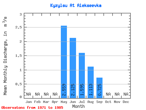
| Statistic | Jan | Feb | Mar | Apr | May | Jun | Jul | Aug | Sep | Oct | Nov | Dec | Annual |
|---|---|---|---|---|---|---|---|---|---|---|---|---|---|
| Mean | 2.56 | 2.12 | 1.59 | 1.11 | 0.72 | ||||||||
| Standard Deviation | 2.78 | 1.32 | 0.85 | 0.59 | 0.42 | ||||||||
| Min | 0.60 | 0.18 | 0.35 | 0.25 | 0.43 | ||||||||
| Max | 11.10 | 3.59 | 3.08 | 2.59 | 1.02 | ||||||||
| Coefficient of Variation | 1.09 | 0.62 | 0.53 | 0.53 | 0.57 |
 Return to R-Arctic Net Home Page