|
|
|||||||||||||||||
| Point ID: 868 | Downloads | Plots | Site Data | Code: 07EE004 |
|
|
|||||||||||||||||
| Download | |
|---|---|
| Site Descriptor Information | Site Time Series Data |
| Link to all available data | |
| View: | Time Series | All |
| Units: | mm |
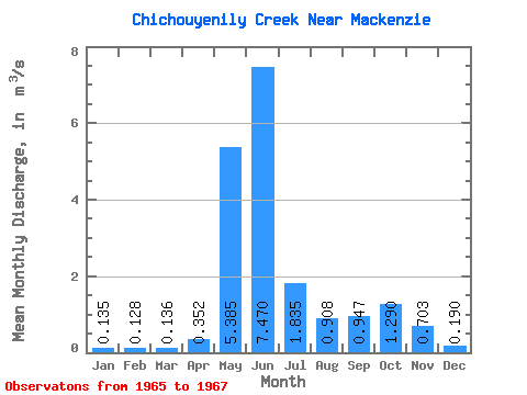
| Statistic | Jan | Feb | Mar | Apr | May | Jun | Jul | Aug | Sep | Oct | Nov | Dec | Annual |
|---|---|---|---|---|---|---|---|---|---|---|---|---|---|
| Mean | 0.14 | 0.13 | 0.14 | 0.35 | 5.38 | 7.47 | 1.83 | 0.91 | 0.95 | 1.29 | 0.70 | 0.19 | 1.64 |
| Standard Deviation | 0.03 | 0.03 | 0.03 | 0.06 | 0.56 | 2.63 | 1.02 | 0.85 | 0.99 | 0.18 | 0.12 | 0.01 | |
| Min | 0.12 | 0.11 | 0.11 | 0.31 | 4.99 | 5.61 | 1.11 | 0.31 | 0.24 | 1.08 | 0.62 | 0.18 | 1.64 |
| Max | 0.15 | 0.15 | 0.16 | 0.39 | 5.78 | 9.33 | 2.56 | 1.51 | 1.65 | 1.41 | 0.79 | 0.20 | 1.64 |
| Coefficient of Variation | 0.18 | 0.24 | 0.24 | 0.16 | 0.10 | 0.35 | 0.56 | 0.94 | 1.05 | 0.14 | 0.17 | 0.07 |
 Return to R-Arctic Net Home Page