|
|
|||||||||||||||||
| Point ID: 8677 | Downloads | Plots | Site Data | Code: 11593 |
|
|
|||||||||||||||||
| Download | |
|---|---|
| Site Descriptor Information | Site Time Series Data |
| Link to all available data | |
| View: | Time Series | All |
| Units: | mm |
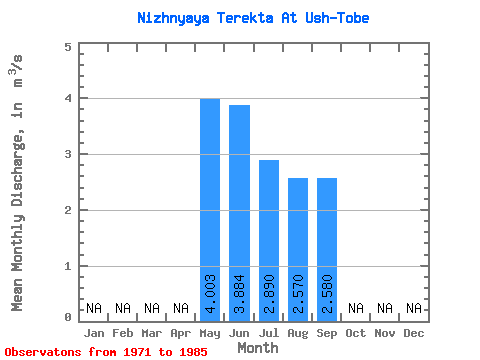
| Statistic | Jan | Feb | Mar | Apr | May | Jun | Jul | Aug | Sep | Oct | Nov | Dec | Annual |
|---|---|---|---|---|---|---|---|---|---|---|---|---|---|
| Mean | 4.00 | 3.88 | 2.89 | 2.57 | 2.58 | ||||||||
| Standard Deviation | 5.21 | 5.27 | 3.86 | 2.99 | 2.45 | ||||||||
| Min | 0.60 | 0.42 | 0.24 | 0.18 | 0.69 | ||||||||
| Max | 17.70 | 17.90 | 12.60 | 9.11 | 7.65 | ||||||||
| Coefficient of Variation | 1.30 | 1.36 | 1.33 | 1.16 | 0.95 |
 Return to R-Arctic Net Home Page