|
|
|||||||||||||||||
| Point ID: 8669 | Downloads | Plots | Site Data | Code: 11527 |
|
|
|||||||||||||||||
| Download | |
|---|---|
| Site Descriptor Information | Site Time Series Data |
| Link to all available data | |
| View: | Time Series | All |
| Units: | mm |
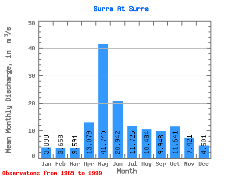
| Statistic | Jan | Feb | Mar | Apr | May | Jun | Jul | Aug | Sep | Oct | Nov | Dec | Annual |
|---|---|---|---|---|---|---|---|---|---|---|---|---|---|
| Mean | 3.90 | 3.66 | 3.59 | 13.08 | 41.74 | 20.94 | 11.72 | 10.48 | 9.95 | 11.64 | 7.42 | 4.50 | 11.76 |
| Standard Deviation | 0.61 | 0.70 | 0.78 | 11.11 | 19.27 | 10.65 | 8.04 | 8.78 | 5.55 | 8.74 | 4.74 | 1.36 | 3.31 |
| Min | 2.75 | 1.91 | 1.34 | 3.75 | 9.26 | 3.95 | 3.12 | 3.34 | 4.18 | 3.91 | 3.43 | 2.63 | 4.90 |
| Max | 4.92 | 5.04 | 5.95 | 42.40 | 81.20 | 46.40 | 32.30 | 42.40 | 22.00 | 37.60 | 22.60 | 8.77 | 18.46 |
| Coefficient of Variation | 0.16 | 0.19 | 0.22 | 0.85 | 0.46 | 0.51 | 0.69 | 0.84 | 0.56 | 0.75 | 0.64 | 0.30 | 0.28 |
 Return to R-Arctic Net Home Page