|
|
|||||||||||||||||
| Point ID: 8655 | Downloads | Plots | Site Data | Code: 11469 |
|
|
|||||||||||||||||
| Download | |
|---|---|
| Site Descriptor Information | Site Time Series Data |
| Link to all available data | |
| View: | Time Series | All |
| Units: | mm |
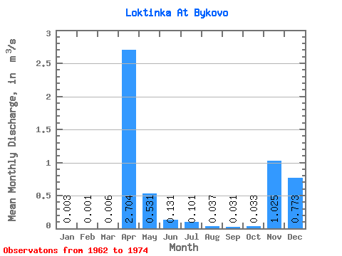
| Statistic | Jan | Feb | Mar | Apr | May | Jun | Jul | Aug | Sep | Oct | Nov | Dec | Annual |
|---|---|---|---|---|---|---|---|---|---|---|---|---|---|
| Mean | 0.00 | 0.00 | 0.01 | 2.70 | 0.53 | 0.13 | 0.10 | 0.04 | 0.03 | 0.03 | 1.02 | 0.77 | 0.30 |
| Standard Deviation | 0.01 | 0.00 | 0.02 | 2.86 | 0.84 | 0.15 | 0.11 | 0.03 | 0.03 | 0.03 | 3.60 | 2.74 | 0.32 |
| Min | 0.00 | 0.00 | 0.00 | 0.25 | 0.02 | 0.02 | 0.01 | 0.00 | 0.00 | 0.00 | 0.01 | 0.00 | 0.03 |
| Max | 0.02 | 0.01 | 0.06 | 10.40 | 3.00 | 0.56 | 0.31 | 0.08 | 0.07 | 0.09 | 13.00 | 9.90 | 1.21 |
| Coefficient of Variation | 1.62 | 3.46 | 2.90 | 1.06 | 1.59 | 1.16 | 1.12 | 0.88 | 0.84 | 0.98 | 3.51 | 3.55 | 1.06 |
 Return to R-Arctic Net Home Page