|
|
|||||||||||||||||
| Point ID: 8642 | Downloads | Plots | Site Data | Code: 11364 |
|
|
|||||||||||||||||
| Download | |
|---|---|
| Site Descriptor Information | Site Time Series Data |
| Link to all available data | |
| View: | Time Series | All |
| Units: | mm |
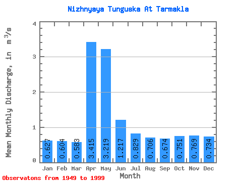
| Statistic | Jan | Feb | Mar | Apr | May | Jun | Jul | Aug | Sep | Oct | Nov | Dec | Annual |
|---|---|---|---|---|---|---|---|---|---|---|---|---|---|
| Mean | 0.63 | 0.60 | 0.58 | 3.42 | 3.22 | 1.22 | 0.83 | 0.71 | 0.67 | 0.75 | 0.77 | 0.73 | 1.17 |
| Standard Deviation | 0.20 | 0.17 | 0.14 | 2.33 | 2.60 | 0.74 | 0.50 | 0.24 | 0.28 | 0.40 | 0.49 | 0.47 | 0.42 |
| Min | 0.24 | 0.32 | 0.35 | 0.78 | 0.50 | 0.38 | 0.34 | 0.32 | 0.25 | 0.29 | 0.32 | 0.26 | 0.44 |
| Max | 1.15 | 1.08 | 0.94 | 9.87 | 11.20 | 3.80 | 2.98 | 1.28 | 1.34 | 1.74 | 2.69 | 3.22 | 2.09 |
| Coefficient of Variation | 0.32 | 0.29 | 0.24 | 0.68 | 0.81 | 0.61 | 0.60 | 0.34 | 0.42 | 0.53 | 0.63 | 0.64 | 0.36 |
 Return to R-Arctic Net Home Page