|
|
|||||||||||||||||
| Point ID: 8639 | Downloads | Plots | Site Data | Code: 11354 |
|
|
|||||||||||||||||
| Download | |
|---|---|
| Site Descriptor Information | Site Time Series Data |
| Link to all available data | |
| View: | Time Series | All |
| Units: | mm |
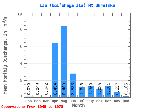
| Statistic | Jan | Feb | Mar | Apr | May | Jun | Jul | Aug | Sep | Oct | Nov | Dec | Annual |
|---|---|---|---|---|---|---|---|---|---|---|---|---|---|
| Mean | 0.09 | 0.05 | 0.04 | 6.45 | 8.48 | 2.82 | 1.25 | 1.36 | 1.04 | 1.30 | 0.63 | 0.19 | 1.99 |
| Standard Deviation | 0.13 | 0.06 | 0.03 | 5.63 | 5.93 | 2.38 | 1.37 | 2.15 | 1.57 | 1.47 | 0.80 | 0.30 | 1.23 |
| Min | 0.01 | 0.00 | 0.01 | 0.32 | 0.45 | 0.21 | 0.03 | 0.01 | 0.02 | 0.02 | 0.01 | 0.01 | 0.11 |
| Max | 0.65 | 0.26 | 0.16 | 17.60 | 24.20 | 8.44 | 4.09 | 6.64 | 6.56 | 4.88 | 3.04 | 1.42 | 4.35 |
| Coefficient of Variation | 1.47 | 1.13 | 0.74 | 0.87 | 0.70 | 0.84 | 1.10 | 1.58 | 1.51 | 1.13 | 1.28 | 1.62 | 0.61 |
 Return to R-Arctic Net Home Page