|
|
|||||||||||||||||
| Point ID: 8636 | Downloads | Plots | Site Data | Code: 11326 |
|
|
|||||||||||||||||
| Download | |
|---|---|
| Site Descriptor Information | Site Time Series Data |
| Link to all available data | |
| View: | Time Series | All |
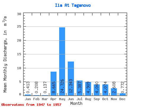
| Units: | mm |
| Statistic | Jan | Feb | Mar | Apr | May | Jun | Jul | Aug | Sep | Oct | Nov | Dec | Annual |
|---|---|---|---|---|---|---|---|---|---|---|---|---|---|
| Mean | 0.41 | 0.21 | 0.14 | 8.66 | 24.73 | 12.34 | 5.39 | 4.91 | 4.04 | 4.07 | 2.61 | 0.77 | 6.29 |
| Standard Deviation | 0.25 | 0.12 | 0.06 | 4.26 | 22.50 | 11.68 | 4.64 | 4.01 | 2.16 | 2.61 | 1.99 | 0.44 | 4.02 |
| Min | 0.10 | 0.08 | 0.08 | 5.09 | 3.08 | 0.65 | 0.33 | 0.08 | 0.02 | 0.01 | 0.01 | 0.00 | 1.13 |
| Max | 0.73 | 0.40 | 0.23 | 16.20 | 58.10 | 32.00 | 13.40 | 10.50 | 6.34 | 7.93 | 6.11 | 1.24 | 11.19 |
| Coefficient of Variation | 0.60 | 0.57 | 0.44 | 0.49 | 0.91 | 0.95 | 0.86 | 0.82 | 0.53 | 0.64 | 0.76 | 0.56 | 0.64 |
 Return to R-Arctic Net Home Page