|
|
|||||||||||||||||
| Point ID: 8618 | Downloads | Plots | Site Data | Code: 11244 |
|
|
|||||||||||||||||
| Download | |
|---|---|
| Site Descriptor Information | Site Time Series Data |
| Link to all available data | |
| View: | Time Series | All |
| Units: | mm |
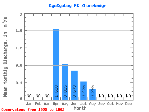
| Statistic | Jan | Feb | Mar | Apr | May | Jun | Jul | Aug | Sep | Oct | Nov | Dec | Annual |
|---|---|---|---|---|---|---|---|---|---|---|---|---|---|
| Mean | 1.63 | 0.83 | 0.68 | 0.43 | 0.26 | ||||||||
| Standard Deviation | 1.46 | 1.02 | 0.71 | 0.39 | 0.08 | ||||||||
| Min | 0.18 | 0.04 | 0.04 | 0.11 | 0.20 | ||||||||
| Max | 4.02 | 2.88 | 1.84 | 0.95 | 0.31 | ||||||||
| Coefficient of Variation | 0.90 | 1.22 | 1.05 | 0.91 | 0.31 |
 Return to R-Arctic Net Home Page