|
|
|||||||||||||||||
| Point ID: 8610 | Downloads | Plots | Site Data | Code: 11225 |
|
|
|||||||||||||||||
| Download | |
|---|---|
| Site Descriptor Information | Site Time Series Data |
| Link to all available data | |
| View: | Time Series | All |
| Units: | mm |
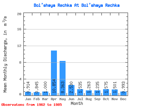
| Statistic | Jan | Feb | Mar | Apr | May | Jun | Jul | Aug | Sep | Oct | Nov | Dec | Annual |
|---|---|---|---|---|---|---|---|---|---|---|---|---|---|
| Mean | 0.91 | 0.84 | 1.00 | 10.85 | 8.36 | 2.53 | 1.54 | 1.26 | 1.23 | 1.57 | 1.50 | 0.99 | 2.73 |
| Standard Deviation | 0.18 | 0.17 | 0.36 | 3.71 | 4.97 | 1.21 | 0.62 | 0.40 | 0.30 | 0.43 | 0.51 | 0.25 | 0.70 |
| Min | 0.61 | 0.52 | 0.47 | 3.65 | 2.42 | 1.09 | 0.68 | 0.65 | 0.80 | 0.81 | 0.72 | 0.51 | 1.57 |
| Max | 1.20 | 1.16 | 2.14 | 19.30 | 20.60 | 5.47 | 3.08 | 2.13 | 1.90 | 2.57 | 2.62 | 1.52 | 4.34 |
| Coefficient of Variation | 0.20 | 0.20 | 0.36 | 0.34 | 0.59 | 0.48 | 0.40 | 0.32 | 0.24 | 0.28 | 0.34 | 0.25 | 0.26 |
 Return to R-Arctic Net Home Page