|
|
|||||||||||||||||
| Point ID: 8600 | Downloads | Plots | Site Data | Code: 11202 |
|
|
|||||||||||||||||
| Download | |
|---|---|
| Site Descriptor Information | Site Time Series Data |
| Link to all available data | |
| View: | Time Series | All |
| Units: | mm |
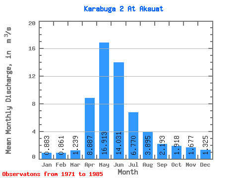
| Statistic | Jan | Feb | Mar | Apr | May | Jun | Jul | Aug | Sep | Oct | Nov | Dec | Annual |
|---|---|---|---|---|---|---|---|---|---|---|---|---|---|
| Mean | 0.88 | 0.86 | 1.24 | 8.89 | 16.91 | 14.03 | 6.77 | 3.90 | 2.19 | 1.92 | 1.68 | 1.32 | 5.05 |
| Standard Deviation | 0.38 | 0.28 | 0.55 | 10.36 | 8.76 | 7.90 | 5.52 | 2.77 | 1.29 | 0.63 | 0.71 | 0.72 | 2.74 |
| Min | 0.48 | 0.35 | 0.51 | 1.99 | 7.46 | 5.14 | 2.11 | 1.33 | 0.74 | 0.61 | 0.79 | 0.53 | 2.50 |
| Max | 1.94 | 1.56 | 2.54 | 44.50 | 34.20 | 32.70 | 21.50 | 11.20 | 5.71 | 2.93 | 3.22 | 2.62 | 11.40 |
| Coefficient of Variation | 0.42 | 0.33 | 0.45 | 1.17 | 0.52 | 0.56 | 0.81 | 0.71 | 0.59 | 0.33 | 0.43 | 0.54 | 0.54 |
 Return to R-Arctic Net Home Page