|
|
|||||||||||||||||
| Point ID: 8575 | Downloads | Plots | Site Data | Code: 11142 |
|
|
|||||||||||||||||
| Download | |
|---|---|
| Site Descriptor Information | Site Time Series Data |
| Link to all available data | |
| View: | Time Series | All |
| Units: | mm |
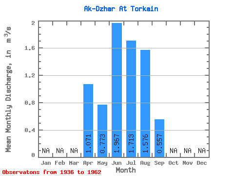
| Statistic | Jan | Feb | Mar | Apr | May | Jun | Jul | Aug | Sep | Oct | Nov | Dec | Annual |
|---|---|---|---|---|---|---|---|---|---|---|---|---|---|
| Mean | 1.07 | 0.77 | 1.97 | 1.71 | 1.58 | 0.56 | |||||||
| Standard Deviation | 0.33 | 1.29 | 1.34 | 1.12 | 0.29 | ||||||||
| Min | 1.07 | 0.49 | 0.60 | 0.40 | 0.28 | 0.24 | |||||||
| Max | 1.07 | 1.24 | 3.99 | 3.66 | 3.08 | 1.08 | |||||||
| Coefficient of Variation | 0.42 | 0.65 | 0.78 | 0.71 | 0.52 |
 Return to R-Arctic Net Home Page