|
|
|||||||||||||||||
| Point ID: 8559 | Downloads | Plots | Site Data | Code: 11097 |
|
|
|||||||||||||||||
| Download | |
|---|---|
| Site Descriptor Information | Site Time Series Data |
| Link to all available data | |
| View: | Time Series | All |
| Units: | mm |
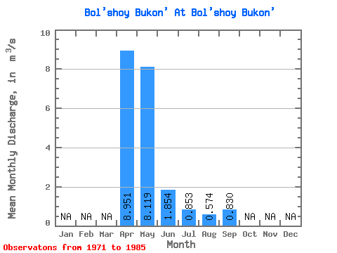
| Statistic | Jan | Feb | Mar | Apr | May | Jun | Jul | Aug | Sep | Oct | Nov | Dec | Annual |
|---|---|---|---|---|---|---|---|---|---|---|---|---|---|
| Mean | 8.95 | 8.12 | 1.85 | 0.85 | 0.57 | 0.83 | |||||||
| Standard Deviation | 7.74 | 8.44 | 1.73 | 0.84 | 0.74 | 0.94 | |||||||
| Min | 1.73 | 0.63 | 0.18 | 0.16 | 0.12 | 0.22 | |||||||
| Max | 23.50 | 30.30 | 5.54 | 3.30 | 2.85 | 3.13 | |||||||
| Coefficient of Variation | 0.86 | 1.04 | 0.93 | 0.98 | 1.29 | 1.14 |
 Return to R-Arctic Net Home Page