|
|
|||||||||||||||||
| Point ID: 8553 | Downloads | Plots | Site Data | Code: 11083 |
|
|
|||||||||||||||||
| Download | |
|---|---|
| Site Descriptor Information | Site Time Series Data |
| Link to all available data | |
| View: | Time Series | All |
| Units: | mm |
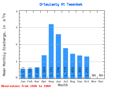
| Statistic | Jan | Feb | Mar | Apr | May | Jun | Jul | Aug | Sep | Oct | Nov | Dec | Annual |
|---|---|---|---|---|---|---|---|---|---|---|---|---|---|
| Mean | 0.57 | 0.58 | 0.65 | 1.36 | 3.19 | 2.60 | 1.78 | 1.45 | 1.36 | 1.29 | |||
| Standard Deviation | 0.66 | 1.70 | 1.61 | 1.19 | 1.26 | 0.53 | |||||||
| Min | 0.57 | 0.58 | 0.65 | 0.57 | 1.32 | 0.68 | 0.37 | 0.30 | 0.88 | 1.29 | |||
| Max | 0.57 | 0.58 | 0.65 | 2.38 | 7.96 | 7.66 | 5.16 | 5.05 | 2.30 | 1.29 | |||
| Coefficient of Variation | 0.49 | 0.53 | 0.62 | 0.67 | 0.87 | 0.39 |
 Return to R-Arctic Net Home Page