|
|
|||||||||||||||||
| Point ID: 8542 | Downloads | Plots | Site Data | Code: 11010 |
|
|
|||||||||||||||||
| Download | |
|---|---|
| Site Descriptor Information | Site Time Series Data |
| Link to all available data | |
| View: | Time Series | All |
| Units: | mm |
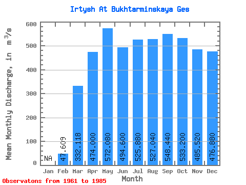
| Statistic | Jan | Feb | Mar | Apr | May | Jun | Jul | Aug | Sep | Oct | Nov | Dec | Annual |
|---|---|---|---|---|---|---|---|---|---|---|---|---|---|
| Mean | 47.61 | 332.12 | 474.00 | 572.08 | 494.60 | 525.88 | 527.04 | 548.44 | 533.20 | 485.52 | 476.88 | ||
| Standard Deviation | 26.24 | 97.52 | 283.04 | 198.28 | 93.39 | 74.85 | 83.80 | 102.10 | 90.62 | 102.89 | 147.83 | ||
| Min | 1.00 | 213.00 | 40.00 | 183.00 | 239.00 | 375.00 | 384.00 | 370.00 | 382.00 | 320.00 | 229.00 | ||
| Max | 99.00 | 638.00 | 994.00 | 915.00 | 692.00 | 713.00 | 694.00 | 783.00 | 754.00 | 732.00 | 848.00 | ||
| Coefficient of Variation | 0.55 | 0.29 | 0.60 | 0.35 | 0.19 | 0.14 | 0.16 | 0.19 | 0.17 | 0.21 | 0.31 |
 Return to R-Arctic Net Home Page