|
|
|||||||||||||||||
| Point ID: 8524 | Downloads | Plots | Site Data | Code: 10560 |
|
|
|||||||||||||||||
| Download | |
|---|---|
| Site Descriptor Information | Site Time Series Data |
| Link to all available data | |
| View: | Time Series | All |
| Units: | mm |
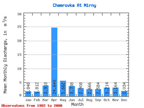
| Statistic | Jan | Feb | Mar | Apr | May | Jun | Jul | Aug | Sep | Oct | Nov | Dec | Annual |
|---|---|---|---|---|---|---|---|---|---|---|---|---|---|
| Mean | 1.85 | 1.81 | 3.92 | 24.64 | 5.66 | 3.74 | 2.91 | 2.67 | 2.58 | 3.21 | 3.16 | 2.03 | 4.85 |
| Standard Deviation | 0.12 | 0.14 | 2.25 | 10.52 | 1.66 | 0.78 | 0.69 | 0.44 | 0.35 | 0.42 | 0.20 | 0.35 | 1.13 |
| Min | 1.66 | 1.57 | 2.12 | 15.90 | 2.83 | 2.79 | 2.15 | 2.15 | 2.16 | 2.76 | 2.84 | 1.62 | 3.59 |
| Max | 1.95 | 1.93 | 7.76 | 41.90 | 7.01 | 4.72 | 3.96 | 3.14 | 3.09 | 3.82 | 3.35 | 2.50 | 6.49 |
| Coefficient of Variation | 0.06 | 0.08 | 0.57 | 0.43 | 0.29 | 0.21 | 0.24 | 0.17 | 0.13 | 0.13 | 0.06 | 0.17 | 0.23 |
 Return to R-Arctic Net Home Page